Rating: strenuous
Length:
· 27.5 km from Similkameen/Windy Joe/PCT Trail head to Frosty Summit to Lightning Lake Day Use to Similkameen/Windy Joe/PCT
· 22.2 km from Lightning Lake to summit and return
· 29 km from Similkameen/Windy Joe/PCT to summit return
Elevation Change:
· 1150 m from Lightning Lake
· 1200 m from Similkameen/Windy Joe/PCT
Time: 8 to 10 hours return, or overnight at either Frosty Creek Wilderness Campsite (Lightning Lake side) or Pacific Crest Trail Wilderness Campsite (Windy Joe side).
Start of Trail: Lightning Lake Day Use Area parking lot or Similkameen/Windy Joe/PCT parking lot.
Best Time to Go: July to September. Late July to mid-August there are lots of wild flowers to see. About the third week of September the stand of sub-alpine Larch changes colour to gold. Well worth a hike then, especially as the days are cooler and usually sunny.
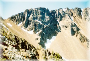
With an elevation of 2423 m, Frosty Mountain is the highest mountain in the park. To reach the first and only safely accessible peak (2408 m), the hiker passes through a great variety of habitats; from lake side forest and sub-alpine meadow to larch forest and true alpine.
The Frosty Mountain trail is, for the most part, on the north-facing slope, making it one of the last trails in the park to be free of snow. Although accessible by late June, there is the possibility that the summit cannot be reached due to snow. As cornices along the ridge can be extremely dangerous, travel on them is risky.
Peak flower season is generally the first two weeks of August. Prior to that, the "Spring" bloom and a variety of fungi are of interest. From mid-September through early October, the golden fall colours of the Larch and Vaccinium are spectacular, and the variety of fungi is extensive.
LIGHTNING LAKE START: Leaving the Lightning Lake Day Use area, cross the bridge over the dam on the east side of the lake. About 100 m south of the bridge, take the left fork of the trail and head up a small scree slope. The switchbacks during the first 6 km take you through a lush Engelmann Spruce and sub-alpine Fir forest with an undergrowth of Wild Rhododendrons, Falsebox, Tall Mountain Huckleberry and Trailing Rubus. Please follow the trails to prevent further erosion caused by cutting corners. After about 45 minutes, you will enjoy the first of many views down to Lightning and Flash Lakes. Look for Silvertip Mountain behind the ski hill and Mount Hozameen off to the southwest. The forest occasionally opens to gorgeous meadows of Lupine, Arnica and Mountain Valerian.
Another good hour of walking (7 km from Lighting Lake Day use) brings the hiker to Frosty Creek wilderness campsite at 1850 m elevation. There is a shelter here for inclement weather conditions, however, come prepared, it may already be in use. A small creek runs through the campsite; when moving on be sure to fill your water bottles here.
From Frosty Creek another .5 km or 30 minutes of steep trail leads to the Larch grove. The forest opens slightly during this ascent to expose a scree slope sprinkled with plants such as Lance-leafed Stonecrop. Note how its fleshy leaves hold much needed moisture for the plant. The views continue to be spectacular. Half a kilometre into the Larch grove, the grade of the trail lessens. Undergrowth has shrunk in size; Pussytoes, Partridge Foot, Red Heather, Wood Rush and other small, hardy plants thrive here. Alpine Larch are truly beautiful, especially in fall against the magnificent backdrop of Frosty Mountain's westerly peak.
At approximately 10 km, both peaks of Frosty Mountain loom ahead. The Larch forest suddenly ends, and a much more austere habitat begins. The scree slope is dotted with multi-coloured Crustose Lichen. Cushion plants, such as Moss Campion and Whitlow Grass cling to the rock, keeping low and out of the dry wind. These plants take years to establish themselves; please take care not to step on them when scrambling up the rocks. Pika can be heard peeping out warnings to one another, and are sometimes seen scurrying from boulder to boulder. In August, look overhead for raptures such as the Sharpshinned Hawk. 1.5 km of steep switchbacks lead to the ridge and to the junction with the Windy Joe side of the trail. Those with overnight packs may prefer to leave most of their gear at the junction before ascending the last .6 km along the ridge to the summit.
The view in every direction is incredible; allow for a long rest here. From the north, counter-clockwise, look for these mountains: Three Brothers, Snass, Outram, Silvertip, Finlayson & Wright, Spickard to the west, Winthrop to the east and then Chuwantum. On a warm sunny day, watch for lady bugs, Mountain Swallowtails, Fritillarias, Supphurs and other butterflies (and the Deer Fly with its large jaws) that may join you at the top. Back at the crossroads, retrace your steps to Lightning Lake or start down towards Windy Joe Mountain
The scree slope on Windy Joe (eastern) side of the ridge is not as steep as the western slope. After about half an hour, the rock slope merges into a meadow resplendent with Western Anemone, Red and White Paintbrush, Wood Betony and Lupine. The flowers tend to bloom a little later here than on the western slope. From the meadow, the views continue to be breathtaking.
The forest gradually thickens after 14 km. At 19 km, the junction of the Pacific Crest Trail is reached. Those who want to spend another night in the forest should turn right and proceed about 200 m to the Pacific Crest wilderness campsite. No shelter is provided here but there is an outhouse and a good water source. The gentle stream that flows through the camp is the first on this side of the mountain. Those continuing down will encounter another stream nearby.
Head west along the Similkameen trail at about the 24.3 km point. Follow this route to the Gibson Pass Road and then continue along the Little Muddy trail (which loosely parallels the road) to the Lightning Lake Day Use area parking lot.